Nawaf Bahadur
Level Designer
Loading...
Loading...
Far Cry 5 Inspired Map built in UE4
For Ubisoft NEXT Challenge
Platform:
Windows PC
Engine:
Unreal Engine 4
Language:
Blueprint Visual Scripting
Tools Used:
Unreal Engine 4, PowerPoint, Ubisoft FPS pack
Duration:
30 workdays
Completion:
Complete
Team Size:
1
Role:
Concept, design flow, BSP placement, prop and
texture placement, lighting, enemy spawns, pathfinding. Blueprint scripting
Overview:
For Ubisoft Toronto's 2019 NEXT level design competition, I created a level based on Far Cry 5 that accounted for both stealth and run n gun play styles based on provided specifications and metrics.
I connected the scenario to FC5's story and map. Started with basic block out maps on paper and then created it in Unreal Engine 4. I also iterated on sight-lines, path-flows, kill affordances, and progression based on feedback from playtesters. The competition was administrated in phases including a curve-ball that changed the story and requirements towards the end.
I won 3rd place at the Ubisoft NEXT 2019 Level Design competition.

3rd Place
Pathing: Gamifying The Real World
First of all, I needed to examine the site. I used Earth View in Google Maps to view 3D models of Ontario Place. I needed that to get a general feel of the relationship of the buildings to their surroundings. I then looked in Far Cry 5's map and found a couple of spots I can plop in my level. One such spot is Elk Jaw Lodge is located. Look at the image A.


A
B
B1
B2
B3
And by tracing the buildings in image B, I could also have a good starting point in terms of the level structure. You can also see the triangular building at B1 being the CNE Ontario Government Building; B2 is where the wind turbine is, B3 is where the entrance to Ontario Places' Pods and Cinesphere are.
I had a couple of objectives when making the map:
-
Compress the play area to a 'walk-able' square area
-
Shift around structures to create interesting sight-lines and landmarks(more on that in the next section)
-
Maintain the feel of traversing the real-world location, especially the entrance bridge
-
Make the player feel small
I enjoy dissecting maps and that what I did here. I snipped bits and pieces from Google Maps and experimented with the arrangements of the buildings and spaces.
I moved the CNE Ontario Government Building and the wind turbine closer. then duplicated the turbine to fill in more space. It makes more sense to have a wind farm of multiple turbines in Far Cry 5's rural setting than one niche turbine-like in Toronto's urban setting.
Most of the islands on the east and west have been removed and streamlined. The buildings on the east island were too big and sparse and could be their own maps. A similar thing applied to the west island, but I kept the silos (the white circles on the left) from the water park and pushed it closer to the Pods(the diamond buildings at the center). My thinking is that the silos would create a lot of visual interest as an abandoned piece of infrastructure that would be located within the approach zone.
I also removed the docks at the south as they would get in the way of approaching the level from that direction.
After figuring out the basic layout, it became a little easier and intuitive to start imagining connections between the buildings. I added the red lines to make the pathways a bit more visible.

C


C
D
Then I sketched that into sticky notes to further explore the pathing. (as shown in images C and D.)
With a general idea of the buildings and pathing set. I can finally move to bubble diagrams to further solidify the level layout. I sketched a general diagram. (Image E) and then a more fine-grained one. (Image F) note that this is only looking at the general connections between the buildings and rooms, irrespective of the floors and grade variations.


E
F
I decided not to make an actual bubble diagram at this stage as it will become confusing and illegible very fast. I went to create the ground floor map and the exterior maps first.
Creating Maps
I started by blocking out the exterior walls (Image G) before I could start exploring the spaces inside. I had an objective of using as much of the space inside the Pods in the hopes it will make people notice how the internal and external structures work together. You will notice at the bottom right Pod that their's an amphitheater-like room that had to be reoriented a couple of times while exploring the pathing. (Image G) I also found out later that it was useful to have the seating directed the door as it helped people find their way. With the general room layouts set, I started exploring and moving around enemy paths and shifted around some room obstacles to provide cover and hidings spots. (Image H)
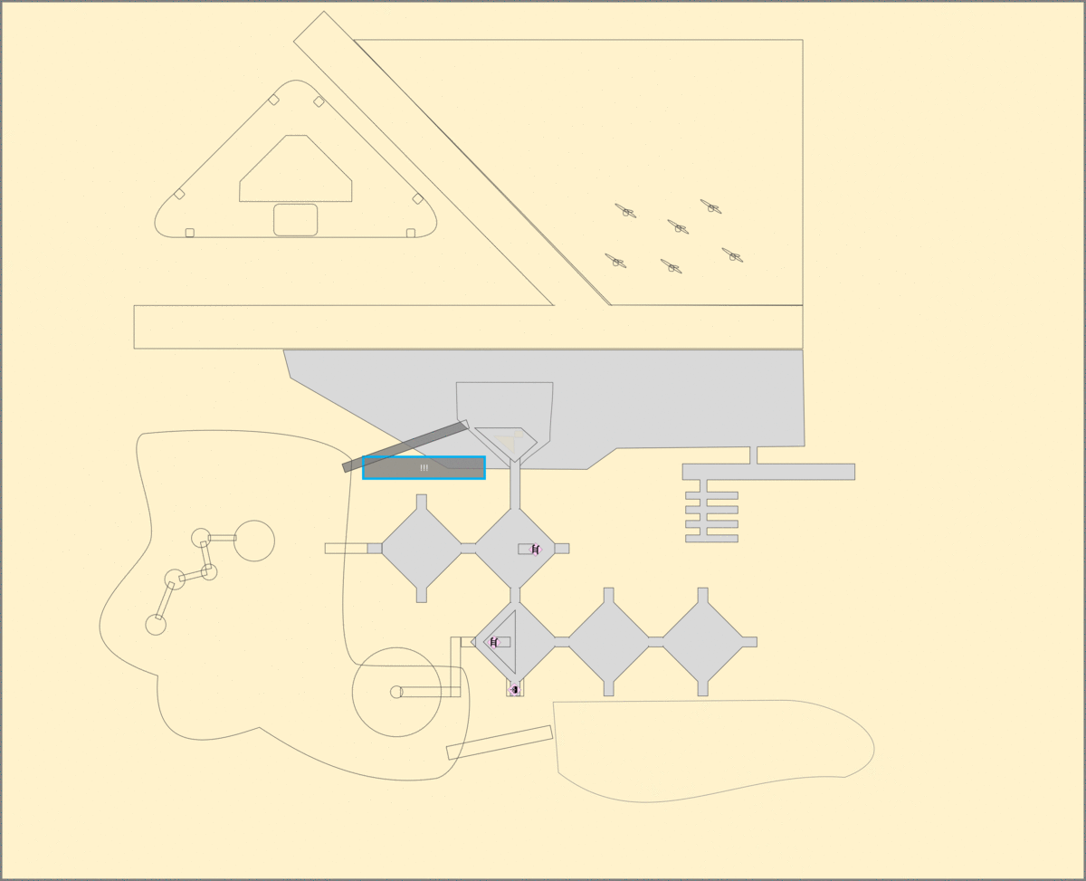

G
H
Around the same time, I also started thinking of the exterior portion of the map. At this point I have been using the traced version of the map (Images G & I) and still had the CNE Ontario Building (top left of Image G) and had the wind mills clustered at the north east of the map. I decreased the size of the West Island, which was also a huge blob that was big enough to be a level on its own. So I decreased it's size further. (It's even bigger in real life. See image B above). I also cut out the CNE Ontario Building for the same sizing issue and spread out the wind turbines into a more of a line like I have seen in photos online. (See Image 5 in the Reference section below).

I
J
Finally, I had all the ingredients I needed to make a map for the connections between floors. The map has many pathing options to follow Ubisof's 360 approach and I needed a map to communicate these pathways. (Image K) Note some of the rooms in Image I was changed after playtesting.

K
Choosing The Location
Ubisoft is known for gamifying real-world locations in their games. Assasin's Creed uses historical locations and makes them fun to climb and hide in. Watch Dogs takes modern Cities and adds 'hacking' to objects in these cities in an intuitive way. Far Cry, the reference for this competition, does a great job turning real wold rural and undeveloped lands into a fun no man's land that the player can imagine themselves saving.
I knew early on that I wanted to choose a location from the real world to follow Ubisoft's habits. So I started searching for locations. I had 5 loose criteria for choosing a place:
-
Has to be a real location
-
Has a big natural element to tie it to Far Cry
-
Has interesting topology
-
Be big to showcase my talents in a complex level
-
Can be placed into Far Cry 5's world map
Below are some places I explored before making a decision.


My sketch/trace of the Port Lands.
Render of how it could look like Courtesy of Waterfront Toronto.
Valier's Island, Toronto, Ontario
The island does not technically exist right now but it will in 2023 when the flood protection project there is complete. The area is envisioned to become a new mixed-use neighborhood just east of the Toronto downtown. It will be very urban with a lot of mid and high rise buildings expected to be built in the middle. It does have a natural element, however. The protection plan will create huge marshlands making up the edges of the island. I found the mix of both urban and natural elements to be very interesting, especially the potential to create water pathways. I would also make the area smaller and more village-like to fit with Far Cry better.
Ultimately I thought it fit all the criteria well but once I sketched it I realized that there would be too many approach directions. Also, making the island smaller and village-like will make it harder to justify adding an elevator in the space, which is a requirement for the VIP to leave the building(Elevators were later removed in the curveball in phase 2 though). This would have been perfect for Watch Dogs though.
I put aside as a potential location.
Shimao Wonderland InterContinental, Shanghai, China
This new hotel is built inside an abandoned quarry about 30 km outside of Shanghai. This has created an incredible structure that's attached to the quarry's walls for stabilization. It also provides for a very cool open space inside the hotel filled with greenery, and underground levels that have glass walls into an aquarium attached to the pond filled inside the quarry.
The hotel is surrounded by farmlands and roads, making it perfect for adapting to Far Cry's world. I can imagine it as a secret base hidden away in the jungle with a lot of terraces and open spaces for the player to climb and sneak in. The verticality of the space would have allowed for exciting pathways in and out. Elevators would be easy to locate in a building with a lot of open space like this.
Regardless of nitpicking, I liked this location. It had a lot of potential.


My top-down drawing.
A big atrium inside provides a lot of light and greenery. Perfect for vertical pathfinding.
The site area is large but works perfectly in a Far Cry setting.
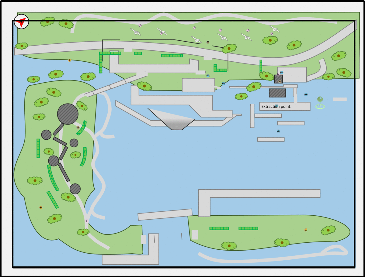
Park map courtesy of Ontario Place

From Modern Canadian Architecture by Leon Whiteson, 1981

Ontario Place, Toronto, Ontario
At this point I had trouble imagining my previous ideas in Far Cry 5's setting. So I started brainstorming places I knew that were a closer fit. One such place was Ontario Place. It's basically a deserted theme park now with amazing architecture. The 'Pods' seemed like they were floating above the water. And as a collection of multi story buildings it would be perfect to show my skills by constructing an intricate map.
For background, the Ontario government wanted to build on the success of its pavilion at Montreal's Expo 67. So they decided to replace the CNE Ontario Government Building with a new building that showcased Ontario. It later became a theme park that was slowly shut down over time.
This place can work in Far Cry 5 as it's a public/ government-owned facility. FC5 has multiple government facilities like PIN-K0 Radar-Station and Mastodon Geothermal Park. So this one could fit in thematically as another place cultists took over. having the buildings above the lake as well as having many bridges provides interesting topology.
I chose to go forward with Ontario Place.
Visual References
Below are some of the reference images I used in my Mission Design Document and while creating the map. I wanted to go to Ontario Place for a long time and this was the perfect opportunity to go and photograph.
11

1
2
3
4
5
6
7
8
9
10
11
11
12
13
13


(actually is the main entrance bridge in the real Ontario Place)


It's the CineSphere, the world first permanent IMAX theater.


